Figure 1: Regional, local, and site-specific areas of concentration in the Maya forest

To see larger picture, click on this image.
Contemporary communities of the Maya forest are pioneering lands and adapting to environmental conditions that have a long and dynamic tradition stretching back millennia to the ancient Maya civilization. While recent community land use patterns have emerged under different conditions, similar natural and physical resources shaped links that depend on an intricate interwoven alliance between culture and nature. Regardless of contemporary political boundaries, this region shares a common past, is united by the kindred present, and stands threatened by an ominous future. Current land use strategies are demonstrably unsustainable, and the accelerated deterioration of cultural and natural resources could be creating a situation of irreversible damage across the region at every scale. Without a clear appreciation of alternatives, the situation will persist. The El Pilar Program assembles a unique international multi-disciplinary research team that is drawn together by fundamental interests in the integrated science approach to conservation of the Maya forest. The research we are developing integrates cultural, physical, and natural science data on the development of one of the world's most biodiverse regions: the Maya forest. Importantly, our research is aligned with regional and local development activities in the Maya forest of Belize, Guatemala, and Mexico as coordinated with our international partners and in process at the recently discovered and newly declared protected area of El Pilar in Belize and Guatemala.
We are concentrating on the core area of the Classic Period Maya which includes the greater Peten region of the Maya forest incorporating the Usumacinta drainage of Mexico and Guatemala, northern Guatemala, states of Campeche and Quintana Roo Mexico, and Belize. Our research gathers together leading scholars and practitioners working with data pertaining to past human and natural systems, contemporary natural history, biogeography and ethnology, and predictive modeling and forecasting. Local and site-specific data collection are focused at the newly created El Pilar Archaeological Reserve for Maya flora and Fauna, where an innovative participatory conservation model has been founded. In addition, close collaborative relationships with the Consejo Nacional de Areas Protegidas (Guatemala), Government of Belize, as well as the Maya Forest Coalition (newly formed Feb 2001), Wildlife Conservation Society, and Conservation International play important roles in the research.
Figure 1: Regional, local, and site-specific areas of concentration in the Maya forest
To see larger picture, click on this image.
The goals of the research are focused on the creation of a regional model that accounts for the successful evolution of land use patterns of the ancient Maya at the local and site specific levels, models their demise, accounts for the creation of the contemporary Maya forest, and projects future scenarios based on community conservation models and population demography. Incorporated into our program is a strong international education component for students from the US and Maya forest region to participate in the site-specific research, investigation, and conservation. The education design leverages local and international community education awareness and participatory conservation-management programs around the El Pilar Archaeological Reserve of Belize and Guatemala.
The Maya forest region is characterized by limestone ridges covered by a deciduous forest. This verdant jungle thrives on an annual rainfall of 1000-3000 mm mainly from June-January. A drought-like dry-season runs from January-June. Local activities are impacted by this wet/dry sequence today, as they were in the Maya prehistory.
A composite mosaic of regional land resources underwrites the foundation of Late Classic Period settlement distribution and intensity in the Maya forest. Settlement densities are the greatest in the well-drained ridges across the region. Ridge lands are concentrated in the interior and are characterized by shallow, fertile, mollisol soils of excellent quality, representing only 1% of the world's tropics yet up to 50% of the Maya forest. These soils are superior for hand cultivation methods but are inappropriate for industrial methods.
These well-drained zones preferred for Maya settlement are unevenly distributed across the region, resulting in dispersed settlement patterns. There is a distinct relationship between the availability of well-drained ridges, settlement density, and the regional Maya hierarchy. This is evident in the local settlement around El Pilar.
The ancient Maya occupation of the central lowland region can be traced back into the third millennium BC. The material archaeological record, however, is firm for the Middle Preclassic before 1000 BC. Steady settlement expansion typified the first millennium BC, based essentially on household farming decisions. In the Late Preclassic, around 250 BC, land use intensity diversified and civic-ceremonial centers made an appearance across the region. Settlements expanded over the area, focused initially on rivers, then lakes and, ultimately, spread across the entire interior area.
There is ample evidence that the interior Petén area around Tikal dominated the region in the Late Classic Period, AD 600-900. At that time, Maya settlement expansion and construction was at its maximum. Yet Maya cites do not fit traditional notions of urbanism, suggesting a value for "green space" that would allow for the forest garden. Even visual metaphors expressed values they placed on nature. Jaguars, three species of monkey including the Capuchin, locally extinct, and cacao figure prominently in Maya art and iconography. The presence of these animals has habitat implications for the Maya forest.
The centralization process was sustained through AD 900, when the Maya civilization "collapsed". Major administrative and political centers, such as Tikal in the central Petén, witness abrupt halts in public projects; but settlements persist through the Terminal Classic Period (AD 900-1000). Settlement evidence between Tikal and Yaxhá, in the Belize River area, as well as in northern Belize attest to persistent occupation. Further, monument building continued at El Pilar through this period, to cease in the Postclassic.
Many scholars focus on the dramatic Classic Maya collapse, we are most interested in the emergence and subsequent methodical growth of settlement and centers over more than two millennia, amply documented in the archaeological record, and stress the sustained and intensive land use strategies of the ancient Maya. The expansion of occupation and the evolution of social complexity of the Maya were based on gradual rise in population and concomitant land use intensification. Early investments in community development endured over time. This centralization process integrated the populations over a span of more than 1700 years, based on the development and management of the assets of the Maya forest. Environmental dimensions constrained subsistence strategies and cultural developments mediated those constraints.
Throughout the Maya sequence, there are a series of environmental factors that have been identified and interpreted through geological, paleoecological, tephrochonological, archaeological, and historical sources. For example, volcanic eruptions and intensity of volcanic activity in Mesoamerica is of particular interest in the evaluation of environmental inputs as local impacts and ability to distribute large amounts of volcanic ash to stratospheric levels have distinct impacts. The integration of all the distinct data sets into one comprehensive comparative base is critical in the understanding of the complex human and natural processes.
The University of California at Santa Barbara Maya Forest Geographic Information System (GIS) project has focused on assembling available data to cover the greater Maya forest region of Belize, Guatemala, and Mexico. The initial efforts have been supported by an innovative UCSB program called Research Across Disciplines and has provided the basis for our research at the regional level. These data are now combined into a regional GIS destined to be an archived database in the Alexandria Digital Library. Our compilation is based on the GIS developed at 1:250,000 by the Paseo Pantera Consortium for the US Agency for International Development. We have integrated our digitized maps of topography and soils, included Sader's (1999) land use data for the Petén, geo-referenced 11 MSS satellite images, incorporated the local GIS data base developed by Fedick (1989) for the Belize River area (topography, soils, geology, settlement), and included a 1998 1:6,000 photo-mosaic we developed of the El Pilar Archaeological Reserve for Maya flora and Fauna (EPAR). This first version that we have compiled specifically for the UCSB Maya Forest GIS has been shared with our collaborators in Belize and Guatemala.
We continue our interdisciplinary research, compiling the layered geo-reference data of the Maya forest derived from our biocomplexity team of investigators and collaborators from the region. The objective is to accurately document data from the region, from target local areas in Mexico, Guatemala and Belize, and to focus at the site-specific level for the El Pilar Archaeological Reserve Belize/Guatemala. The primary goal of the GIS data collection is to calibrate the evidential and agent-based land use models. The companion goal is to permanently archive the synthetic database for use by regional and international scientists. Working with established cooperative agreements with international partners, we will be expanding our site-specific comparative research to Mexico in association with Nigh of CIESAS, Turner of Clark University, and Fedick and Gómez-Pompa of UC Riverside.
Data for the our research derive from a variety of distinct resources, and involve a significant effort in compilation, and selected efforts at fieldwork to develop the essential bases for the natural/human systems inquiry and analyses. Past environmental dimensions and archaeological resources are dispersed among research centers where common work is ongoing. Much of the contemporary data are gathered in the archives of the team investigators and collaborators, embedded in different GIS data sets across the Maya forest region, found within literatures of the diverse fields represented among the team, amassed in government agencies, university departments, and natural history museums and found in the gray literature from the development, management and community based non-government organizations that are found within the region collaborating with the Selva Maya Coalition. While most of the source materials are near at hand, the collection, incorporation, and development of a common shared GIS in consistent formats and common scales require significant attention. The following outline lists the data sets that are designed for incorporation into a comprehensive GIS to be developed in our research and analyses.
Paleo-environmental (human-environment relations)Archaeology
- pollen records, sediment cores, and botanical remains
- volcanology, tephrochronology and associated ash deposits and signatures
- interpreted local, regional, and global climate history
Ethnohistorical
- architectural monuments
- site survey and settlement transects
- ceramics and stone artifacts
- stratigraphy and chronologies
- artistic motifs, inconographic representations of flora and fauna
- Codices and interpretive accounts of the Maya
- Military, Clerical and administrative accounts
- Travelers and documentary accounts of the region
Maya forest sources (mapping digitizing computer, existing GIS)
Scientists (published/analyzed scientific data)Data sets-3 scales: Site Specific -GPS/transit/transects, Local -50K, Regional -1:250
- brought by co-investigators
- incompatibilities and regularities
- critical: topo, soil, vegetation, hydrology, archaeological sites, political boundaries
- additional: new satellite data, DEMs, land tenure, protected areas, vegetation change
Ethnological, and agroforestry data
Biological and botanical data
Settlement size and composition
Maya forest sources
Paleo-environmental reports
Archaeological reports
Geographic maps, volcanic ash flow distributions
Site-specific data collection standardization
Local scale WofE and AB modeling: geographic/climatic inputs, human systems consumption
Regional scale geographic definition/predictive modeling for climate, natural and human systems
The Maya forest is considered a biodiversity hotspot, ranked second of 25 resources at risk by Population Action International (2000). There are more than 24,000 plants, 5,000 of which are endemic. Yet, data are accumulating that this same forest reveals a low alpha diversity 89-103 species of flowering plants greater than or equal to 1.5cm DBH per ha. and a low beta diversity index of similarity of 0.53-0.71. Given the high economic component, with up to 90% of botanicals listed as useful plants, we are asking what is the role of human systems in the development of the Maya forest, and what are the implications of this issue for the conservation of the Maya forest in the future? If human interventions prove to selectively high grade the species composition to favor their economic needs over 4000 years, what does this mean for the evaluation of the Maya forest? Flora and fauna now recognized to be at risk must have co-evolved with the ancient Maya. Revealing and modeling the complex biosystems relationships is the true mystery of the Maya forest.
Holocene environmental change and human adaptation are critical themes that impact our interpretation of the evolution of tropical ecology, biocomplexity, and the nature of cultural interaction. The functioning and management of tropical environments in the past, their role in biodiversity, and their future in a world of expanding populations is shrouded with myth and generalization. The complexity of the biological and managed ecosystems of the tropics are constrained by moisture and soil nutrients but not by temperature. The elasticity of carrying capacity for human populations has been well demonstrated in the paleontological and archaeological record, as has a relationship with population density and land use intensity.
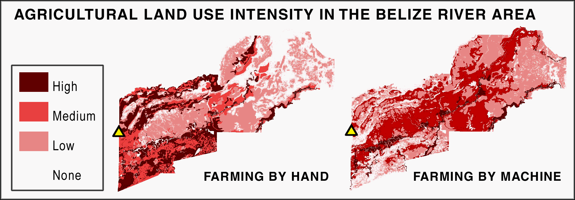
Figure 2: Contrasting land use models for the ancient Maya (Fedick 1989) and contemporary development (Jenkins et al. 1976). The triangle point indicates El Pilar
To see larger picture, click on this image.
Great environmental changes have been wrought on the landscape of today's tropics, and nowhere is this more evident than in lowland Mesoamerica. The Maya forest is the northernmost contiguous stand of the tropical forest. This biologically rich landscape was the location where the ancient Maya evolved a complex civilization creating a home to a population 3 to 9 times that of today. What were the environmental conditions of the Maya pioneers and what caused their demise after more than 3 millennia of sustained agricultural land use?
The complex interrelationship of humans and their environment is encoded in the archaeological settlement patterns left by the Maya, featured in the aesthetic of the elite, and linked to the geographic setting they depended upon. The demise of the civilization leaves a record of land use success, environmental failures, and succession that has the potential to be uncoded through an integrated science effort we and developing in the context of our research. By modeling ancient land use patterns across the Maya region and resolving the evidence at the regional, local and site specific scales, we gain an appreciation of the dynamics of system growth, the self-organizing tension of resilience, the triggers of phase changes, and the potentials for collapse. By compiling data at the same scales for the contemporary forest structure, known economic histories, and contemporary agro-forestry strategies, we can create an explanatory design for the devolution of the Classic Maya system into the present Maya forest. Future trajectories for the Maya forest at risk can be developed based on ethnological models of land use, social cognition and traditional practice, policy and land tenure industrial models for agriculture and climate change. The scenarios can be evaluated in terms of "best practices", using the ancient Maya development pattern and the traditional agro-forestry designs.
As a continuum, we are concentrating on the influences of climatic and environmental change on the one hand and the impacts of human population growth and land use practices on the other. This can be viewed over the entire temporal spectrum of the late Holocene as long-term trends, as well as more short-term events, influences, and interactions. Recognizing the dramatic changes that have transpired in the Maya forest region over the past 5 millennia — the local variations in rainfall regimes, regional stochastic impacts of volcanism, global dimensions of climatic change, as well as the pioneering, expansion, and rise of the Maya civilization — provides a foundation for re-evaluating the interpretations of the Maya prehistory, for understanding the regenerative processes of the Maya forest, and for developing conservation applications for the future. What have been the conditions for the maintenance of the Maya forest? If the co-evolution of the natural and human ecosystems is a fundamental quality of the Maya forest, how are the natural systems separated? What are the conditions of a sustained managed landscape? Are we assessing a feral forest, high-graded through a cultural selective process for economic species in the past and running a new course today?
Our project applies both traditional areas of geographic theory and new predictive methods using weights-of-evidence (WofE) and agent-based modeling to the Maya case. Our Maya forest GIS database developed in collaboration with Belize's Department of Archaeology and Guatemala's Consejo Nacional de Areas Protegidas (CONAP), will be used as the basis for the weights-of-evidence (WofE) analysis and agent based models. We will be working with our wide collaborative base within to investigate geographic factors that contribute to the settlement intensity distributions of the ancient Maya. These in turn can be compared with proposed land use development strategies. Environmental components of our settlement location model will include soils, geology, topographic variables, and surface hydrology as predictor layers with known archeological Maya settlement locations as both actual and predicted locations in the WofE analysis. The strength of associations will provide ranks for environmental contributions to patterns that can be incorporated into the phase changes derived from agent based modeling.
The WofE origins are in mining geology and only recently have the essential tools been integrated into a GIS, ESRI's ArcView 3.2. Gary Raines, who helped build the ArcView extensions for WofE analysis has worked on the Columbia River Basin Ecosystem Management Project and in the development of GIS data standards (http://geology.usgs.gov/dm/). He has joined our group and is enthusiastically collaborating on this project. As developed, WofE analysis follows six steps: 1) select known points of some feature such as farming sites that are to be modeled, 1) select thematic maps that are suspected to contribute to the explanation of a distribution, 2) using the correlation analysis tools of WofE, convert selected map layers to binary or categorical form, 3) test for conditional independence comparing prior and posterior probabilities by class combinations, eliminating those maps which do not contribute explanatory power, 4) create a set of weights to use for each layer using Bayesian methods, and 5) develop posterior probability and the associated uncertainty maps using the weighted layers. The probabilities are then used as environmental weights in the agent based land-use model.
The ranking of Maya forest environment based on land use intensity in the Late Classic Period provides a basis for envisioning the Maya forest at the population peak. We are working to calibrate environmental data across the region, simulate inputs of rainfall change and volcanic ash falls based on tephrochronologies, model population growth and caloric needs, settlement dynamics of rise and decline, as well as dynamics of flora and fauna impact within the changing forest over time.
Household farming strategies of the Maya evolved land use systems within the context of environmental dimensions of soil, topography, and water availability. How can management strategies account for resilience under rising population conditions over the trajectory of growth? Did human land use strategies impact sustainability? We know there were periodic environmental perturbations (drought, volcanic ash, and hurricanes) and that these had major environmental consequences. How were stochastic environmental changes accommodated in the record of the Maya forest? What were the opportunities and threats that may have occurred for human populations? How might the visual metaphors of the charismatic species (jaguar, macaw, and monkey) as documented in patronized art provide insights into ancient Maya resource conservation?
Once the data are collected, integrated, and calibrated, we will be in a position to work with the WofE and agent-based models. We strive to use the modeling process to identify key monitors of stability and change in the coupled human and natural systems of the Maya forest. We look at the process of devolution of the Maya civilization to model the succession of the regenerative forest processes based on the botanical data, alert to unknown behavior and environmental properties are emergent from our system model. Our collaborative efforts focus on the clarification of conditions that lead to the Maya forest of 1697 conquest up to the present.
Figure 3: The Maya house of Tzunu'un at El Pilar and its forest garden

To see larger picture, click on this image.
It has been proposed that traditional human subsistence systems of agroforestry strategies recognized across the Maya lowlands and knowledge of the forest dynamics and resource potentials provide a basis for modeling land use in the past. This can be directly tested and used as a basis for the agent based models. This can assist in assessing human inputs of the ancient Maya model and the structure of the Maya forest today. We can examine the contemporary environmental inputs as predictors of the ancient Maya case and we can assess whether the traditional strategies are conservationist. We are particularly interested how the complexity of the traditional system can account for the biodiversity of the forest. In other words, are the ancient Maya model results compatible with the traditional forest garden strategies, dynamics and structure? This would help in understanding environmental links from the past to the present at the same time it captures lost environmental knowledge of traditional farming practices for the future.
These investigations address the essential qualities of the Maya forest biodiversity and its relationship to human systems. Working with forest gardeners employing traditional strategies in the forest today, we can see interplay and selectivity. In addition, the influence of propagation based natural and human influences on succession can impact long-term quality of the forest. Are these qualities related to the human character of management? What lessons can be drawn from an enhanced understanding of ancient Maya land use patterns that have implications for contemporary land use and settlement in the region and elsewhere?
With 6 billion people on the earth today, and predictions of population doubling in the Central American region in the next 25 years, there is an urgent need to appreciate the human — environment relationship in order to promote conservation with development in the Maya forest. The threats to the integrity of the forest are palpable, loss of forest cover and immigration are correlates of the risks. The El Pilar Program has initiated an integrated regional science design for community participation in the conservation development of El Pilar. Coordinated with Non-Government Organizations in Belize and Guatemala as international partners, we have been using the El Pilar Archaeological Reserve for Maya Flora and Fauna as a hands-on educational laboratory for undergraduate and graduate training, local junior college field projects, community participation programs, and eco-archaeological tourism developments. This broad based educational platform uses the integrated science research (www.usgs.gov/integrated_science/summary.html) as a means to education on multiple levels. The success of this project has been recognized by the Rolex Awards for Enterprise (Anabel Ford Cultural Heritage 2000) and forms the foundation for our research on future models to enhance conservation in the Maya forest and beyond.
We use the El Pilar Program framework to promote the lessons we gather in from the research. We incorporate population data from Population Action International (CI 2001) in an effort to project the future of the Maya forest. We also use the predictive model of Classic Period Maya settlement to target potential areas for the replication of the El Pilar design to benefit long-term conservation requirements of the region. Our hope is that armed with knowledge and lessons from the past that we can project a best practices model for sustainable use and settlement in the Maya forest and other regions of the Central American tropical rainforest.
To see larger picture, click on this image.
Faced with the inevitability of more human inhabitants on our small planet, all need to accommodate food, shelter and procreation , the limits of our resources are at a critical threshold. In the past, we have relied on the resilience of the earth's system; the Maya forest prehistory is a case in point. But today's situation is different and the impacts of humans have reached global proportions. Resource management is one of the most urgent developments and alternatives to the industrial and technological strategies need to be seriously incorporated into our views of the future. With decreasing biodiversity and the focus on biological corridors to link forested environments, we need to draw attention to the nature of the human development corridors and how to make them more compatible with the ecosystem. Human landscapes simplify nature, transform environments towards economic and service roles, and divide culture from nature. A vital future must include an integration of nature and culture, where services such as family land stewardship, local soil development, regional watershed management, and global consideration work across scales and space. The understanding of the dynamics of the Maya forest provides a significant basis for developing an integrated approach to conservation as the ancient Maya sustained a system for millennia, experienced a collapse that certainly can provide insights into thresholds and phase changes in prehistory, and can demonstrate alternatives to current trends.
Further information can be obtained from the websites for the Maya Forest Alliance and the BRASS/El Pilar Archaeological Reserve.
Abrams, E.M. (1994). How the Maya Built Their World: Energetics and Ancient Architecture. Austin, University of Texas Press.
Adams, R.E.W., ed. (1977). The Origins of Maya Civilization. Albuquerque, University of New Mexico Press.
Andrews, E.W. and N. Hammond (1990). "Redefinition of the Swasey phase at Cuello, Belize." American Antiquity 55(3): 570-584.
Andrews, G.F. (1975). Maya Cities: Placemaking and Urbanization. Norman, University of Oklahoma Press.
Ankerson, T.T. (1994). "The Mesoamerican Biological Corridor: The Legal Framework for an Integrated Regional System of Protected Areas." Journal of Environmental Law and Litigation 9: 502-548.
Ankersen, T.T., ed. (1999). "Emerging Trends in Environmental Law and Policy in Mesoamerica." Revista Mesoamerica, Special Edition.
Ankersen, T.T. and H.A. Guillen-Trujillo (1995). Confronting the Crisis: Conservation Law and Policy in the Maya Forest. Gainsville, University of Florida.
Arnold, J.E. and A. Ford (1980). "Statistical Examination of Settlement Patterns at Tikal, Guatemala." American Antiquity 45(4): 713-726.
Arthur, B., S. Durlauf and D. Lane, eds. (1997). The Economy as an Evolving Complex System II, Addison-Wesley.
Ashmore, W., ed. (1981). Lowland Maya Settlement Patterns. Albuquerque, University of New Mexico Press.
Atran, S. (1990). Cognitive Foundations of Natural History, Cambridge University Press.
Atran, S. (1993). "Itza Maya tropical agro-forestry." Current Anthropology 34(5): 633-700.
Atran, S. (1999). Itzaj Maya folk-biological taxonomy, in Folk Biology, eds. D. Medin and S. Atran. Cambridge, MA, MIT Press.
Atran, S. (2000). The Vanishing Landscape of the Peten Maya Lowlands: People, plants, animals, places, words and spirits, in Language, Knowledge, and the Environment, ed. L. Maffi. Washington, D.C., Smithsonian Institution Press.
Atran, S., D. Medin, N. Ross, E. Lynch, J. Coley, E. Ek' Ukan & V. Vapnarsky (1999). "Folkecology and Commons Management in the Maya Lowlands." Proceedings of the National Academy of Sciences of the United States of America, 96: 7598-7603.
Awe, J.J., J. Conlon and M.D. Campbell (1991). "Preliminary analysis of the spatial configuration of the site core at Cahal Pech, Belize and its implications for Lowland Maya social organization." Mexicon 13(2): 25-30.
Axtell, R., R. Axelrod, and M.D. Cohen (1996). "Aligning Simulation Models: A Case Study and Results". Computational and Mathematical Organization Theory 1:2.
Bacon, E.N. (1976). Design of Cities. London, Penguin Books.
Baker, M. (1992). "Capuchin Monkeys and the Ancient Maya." Ancient Mesoamerica 3: 219-228.
Balée, W. and D.G. Campbell (1989). "Ecological aspects of liana forest, Xingu River, Amazonian Brazil." Biotropica 22(1): 36-47.
Balick, M.J. (1994). Ethnobotany, Drug Development, and Biodiversity Conservation-Exploring the Linkages, in Ethnobotany and the Search for New Drugs, 4-24, eds. G.T. Prance, D. Chadwick, and J. Marsh. Chichester, NY, John Wiley and Sons.
Barnes, G. (1995). Land and Geographic Information Systems, in The Surveying Handbook, 880-922, eds. R.C. Brinker and R. Minnick. New York, Chapman and Hall.
Beach, T. (1998). "Soil catenas, tropical deforestation, and ancient and contemporary soil erosion in the Peten, Guatemala." Physical Geography 19(5): 378-405.
Bellinham, P.J., E.V. Tanner, and J.R. Healey (1994). "Sprouting of trees in Jamaican montane forests, after a hurricane." Journal of Ecology 82: 747-758.
Benson, E. (1997). Birds and Beasts of Ancient Latin America, Gainesville, University Press of Florida.
Bonham-Carter, G.F. (1994). Geographic Information Systems for Geoscientists: Modeling with GIS. New York, Pergamon.
Bonham-Carter, G.F. (1999). "Integration of Geological Datasets for Gold Exploration in Nova Scotia." Photogrammetric Engineering and Remote Sensing 54: 1585-1592.
Boserup, E. (1965). The Conditions of Agricultural Growth: the Economics of Agrarian Change under Population Pressure. Chicago, Aldine.
Boserup, E. (1981). Population and Technological Change: A Study of Long-Term Trends. Chicago, University of Chicago Press.
Brenner, M. (1983). "Paleolimnology of the Peten Lake District, Guatemala II. Mayan population density and sediment and nutrient loading of Lake Quexil." Hydrobiologia 103: 205-210.
Brenner, M., D.A. Hodell, J.H. Curtis, M. Rosenmeier, M.W. Binford, and M.B. Abbott (2001). Abrupt climate change and pre-Columbian cultural collapse, in Interhemispheric Climate Linkages, 87-103, ed. V. Markraf. Academic Press.
Bullard, W.R. (1960). "Maya Settlement Pattern in Northeastern Peten, Guatemala." American Antiquity 25(3): 355-372.
Bullard, W. R. (1964). Settlement Pattern and Social Structure in the Southern Maya Lowlands during the Classic Period, in XXXV Congreso Internacional de Americanistas, Vol. 1, 279-287.
Campbell, D.G. (1989). The Quantitative Inventory of Tropical Forests, in Floristic inventory of tropical countries, 523-533, eds. D.G. Campbell and H.D. Hammond. New York, The New York Botanical Garden.
Campbell, D.G. (1994). Scale and patterns of community structure in Amazonian forests, in Large-Scale Ecology and Conservation Biology, 181-199, eds. P.E. & R. May. Oxford, Blackwell.
Campbell, D.G. (1998). Signature of the Classic Maya on the Tropical Forests of Belize. Philadelphia, American Anthropological Association.
Campbell, D.G., J.L. Stone, and A. Rosas (1992). "A comparison of the phytosociology of three floodplain (várzea) forests of known ages, Rio Juruá, western Brazilian Amazon." Botanical J. of the Linnean Society 108: 213-237.
Campbell, D.G., J. Walker, V. Castillo, J. Lake, C. Ocampo-Raeder and S. Smith (1995). The signature of the Classic Maya Empire on Belizean tropical forests. American Association for the Advancement of Science, Atlanta.
Casti, J. (1997). Would-be Worlds: How Simulation is Changing the Frontiers of Science. New York, J. Wiley.
Chase, A. and D. Chase (1992). An Archaeological Assessment of Mesoamerican elites, in MesoAmerican Elites, an Archaeological Assessment, eds. A. and D. Chase. Norman and London, University of Oklahoma Press.
Chase, D. and A. Chase (1988). A postclassic perspective: excavations at the Maya site of Santa Rita Corozal, Belize. San Francisco: Pre-Columbian Art Research Institute.
CIMMYT (1999). World Maize Facts and Trends; Maize Production in Drought-Stressed Environments: Technical Options and Research Resource Allocation. Mexico, DF, CIMMYT.
Clarke, K. and A. Ford (2001). The Maya Forest GIS. New York, American Geographic Association.
Coe, W.R. (1965). "Tikal Guatemala and Emergent Maya Civilization - Excavations Reveal Evidence of Early Complex-Living At a Prime Maya Indian Site." Science 147(3664): 1401-19.
Cohen, M.N. (1977). Population pressure and the origins of agriculture: an archaeological example from the coast of Peru, in Origins of Agriculture, 135-178, ed. C.A. Reed. Chicago, Aldine.
Conservation International (1995). Evaluation of the Selva Maya Map. Washington DC, Conservation International.
Conservation International (2000). Vegetation of the Maya Forest Map. Washington DC, Conservation International.
Coveney, P. and R. Highfield (1995). Frontiers of Complexity: The Search for Order in a Chaotic World. New York, Faber and Faber.
Culbert, T.P., ed. (1973). The Classic Maya Collapse. Albuquerque, University of New Mexico Press.
Culbert, T.P. (1988). The Collapse of Classic Maya Civilization, in The Collapse of Ancient States and Civilizations, 69-101, eds. N. Yoffee and G.L.E. Cowgill. Tucson, University of Arizona Press.
Culbert, T.P. (1991). Polities in the northeast Peten, Guatemala, in Classic Maya Political History: Hieroglyphic and Archaeological Evidence, 128-146, ed. T.P. Culbert. New York, Cambridge University Press.
Culbert, T.P. and D.S. Rice, eds. (1990). Precolumbian Population History in the Maya Lowlands. Albuquerque, University of New Mexico Press.
Curtis, J.H., D.A. Hodell, and M. Brenner (1996). "Climate Variability on the Yucatan Peninsula (Mexico) During the Past 3500 years, and Implications for Maya Cultural Evolution." Quaternary Research 46: 37-47.
Deevey, E.S., D.S. Rice, et al. (1979). "Mayan Urbanism - Impact On a Tropical Karst Environment." Science 206(4416): 298-306.
Denevan, W.M. (1992). "The Pristine Myth: The Landscape of the Americas in 1492." Annals of the Association of American Geographers 82(3): 369-385.
Drexler, J.W., W.I. Rose, R.S.J. Sparks, & M.T. Ledbetter (1980). "The Los Chocoyos Ash, Guatemala: A Major Stratigraphic Marker in Middle America and in Three Ocean Basins." Quaternary Research 13: 327-345.
Duncan, J.S. (1987). "Review of Urban Imagery: Urban Semiotics." Urban Geography 8(5): 473-483.
Dunning, N.P. (1994). Ancient Maya Anthrosols: Soil Phosphate Testing and Land Use, in Proceedings of the First International Conference on Pedo-Archaeology, 203-210, eds. J.E. Foss, M.E. Timpson, and M.W. Morris. Knoxville, University of Tennessee Agricultural Experimentation Station.
Dunning, N.P. (1996). Reexamination of regional variability in the pre-hispanic agricultural landscape, in Managed Mosaic: Ancient Maya Agriculture and Resource Use, 53-68, ed. S.L. Fedick. Provo, University of Utah Press.
Dunning, N., D. Rue, T. Beach, A. Covich, A. Traverse, (1998). "Human-Environment Interactions in a Tropical Watershed: the Paleoecology of Laguna Tamarindito, Guatemala," Journal of Field Archaeology 25: 139-151.
Dunning, N., T. Beach, P. Farrell, and S. Luzzadder-Beach (1998). "Prehispanic Agricultural Adaptive Regions in the Maya Lowlands." Culture and Agriculture 20(4): 87-101.
Dunning, N., V. Scarborough, F. Valdez, Jr., S. Luzzadder-Beach, T. Beach, and J.G. Jones (1999). "Temple Mountains, Sacred Lakes, and Fertile Fields: Ancient Maya Landscapes in Northwestern Belize." Antiquity 73: 650-660.
Dunning, N. and T. Beach (2000). Stability and Instability in Pre-Hispanic Maya Landscapes, in Imperfect Balance: Landscape Transformations in the Precolumbian Americas, 179-202, ed. D. Lentz. New York, Columbia University Press.
Durham, W. H. (1979). Scarcity and Survival in Central America: Ecological Origins of the Soccer War. Stanford, Stanford University Press.
Durham, W. H. (1991). Coevolution: genes, culture, and human diversity. Stanford, Stanford University Press.
Espindola, J., J.L. Macias, R.I. Tilling and M.F. Sheridan (2000). "Volcanic history of El Chichon Volcano (Chiapas, Mexico) during the Holocene, and its impact on human activity." Bulletin of Volcanology 62: 90-104.
FAO (1998). Food Balance Sheets, from http://app.fao.org/page/collections?subset=nutrition.
Fedick, S.L. (1988). Prehistoric Maya Settlement and Land Use Patterns in the Upper Belize River Area, Belize, Central America. Ph.D. dissertation, Arizona State University.
Fedick, S.L. (1989). The Economics of Agricultural Land Use and Settlement in the Upper Belize River Valley, in Prehistoric Maya Economies of Belize (Research in Economic Anthropology, vol 4, Supplement), 215-254, eds. P. McAnany and B.L. Isaac.
Fedick, S.L. (1992). An Agricultural Perspective on Prehistoric Maya Household Location and Settlement Density, in Memorias Del Primer Congreso Internacional de Mayistas; Mesas Redondas, Arquelogía, Epigrafía. Mexico D.F., Universidad Nacional Autónoma de México.
Fedick, S.L. (1995). "Indigenous Agriculture in the Americas." Journal of Archaeological Research 3(4): 257-303.
Fedick, S.L. (1995). "Land Evaluation and Ancient Maya Land Use in the Upper Belize River Area, Belize, Central America." Latin American Antiquity 6(1): 16-34.
Fedick, S.L. (1995). Predicting the Past and Preserving it for the Future: Modeling and Management of Ancient Maya Residential Sites, in The Second Interdisciplinary Conference on Belize, 1-22, ed. M.D. Phillips. Lanham, MD, University Press of America.
Fedick, S.L. (1996). New Perspectives on Ancient Maya Agriculture and Resource Use, in The Managed Mosaic: Ancient Maya Agriculture and Resource Use, ed. S.L. Fedick. Salt Lake City, University of Utah Press.
Fedick, S.L. and A. Ford (1990). "The Prehistoric Agricultural Landscape of the Central Maya Lowlands: An Examination of Local Variability in a Regional Context." World Archaeology 22: 18-33.
Fedick, S.L. and K.A. Taube, eds. (1995). The View from Yalahau: 1993 Archaeological Investigations in Northern Quintana Roo, Mexico, University of California, Riverside: Latin American Studies Program.
Fletcher, R. (1995). The Limits of Settlement Growth: a Theoretical Outline. New York., Cambridge Unversity Press.
Ford, A. (1986). Population Growth and Social Complexity: an Examination of Settlement and Environment in the Central Maya Lowlands. Tempe, Arizona State University.
Ford, A. (1990). Maya Settlement in the Belize River Area: Variations in Residence Patterns of the Central Maya Lowlands, in Precolumbian Population History in the Maya Lowlands, 167-181, eds. T.P. Culbert and D.S. Rice. Albuquerque, University of New Mexico Press.
Ford, A. (1991). "Problems with the evaluation of population from settlement data: examination of ancient Maya residence patterns in the Tikal-Yaxhá� intersite area." Estudios de cultura Maya(18): 157-186.
Ford, A. (1992). The Ancient Maya Domestic Economy: An Examination of Settlement in the Upper Belize River Area, in Primer Congreso Internacional de Mayistas, 57-86. Universidad Nacional Autónoma de Mexico.
Ford, A. (1994). "Arqueología de Acción en la Selva: Creación de la reserva arqueológica de El Pilar, Guatemala-Belice." Utzib 1(7): 19-21.
Ford, A. (1996). Critical Resource Control and the Rise of the Classic Period Maya, in The Managed Mosaic: Ancient Maya Agriculture and Resource Use, 297-303, ed. S.L. Fedick. Salt Lake City: University of Utah Press.
Ford, A., ed. (1998). The Future of El Pilar: the Integrated Research and Development Plan for the El Pilar Archaeological Reserve for Maya Flora and Fauna, Belize-Guatemala. Washington, Bureau of Oceans and International Environmental and Scientific Affairs.
Ford, A. (2001). "El Pilar: Gateway between Belize and Guatemala." Washington Report on the Hemisphere 21 (1-2): 4-5.
Ford, A. and S. Fedick (1992). "Prehistoric Maya Settlement-Patterns in the Upper Belize River Area - Initial Results of the Belize River Archaeological Settlement Survey." Journal of Field Archaeology 19(1): 35-49.
Ford, A. and. N. Gerardo (1998). Lessons from the Past: Ancient Maya Forest Garden and the Contemporary Maya Forest. Paper presented at: American Anthropological Association Annual Meeting, Philadelphia, PA.
Ford, A. and C. Miller (1997). Creación de la Reserve Arqueológica El Pilar en Guatemala y Belice, in X simposion de Invistigaciones Arqueológicas en Guatemala, 417-426, Guatemala,. Museo Naciconal de Arqueología e Ethnología.
Ford, A. and J.A. Montes (1999). "Environment, Land Use, and Sustainability: Implementation of the El Pilar Archaeological Reserve for Maya Flora and Fauna, Belize-Guatemala." Mesoamérica 37: 31-50.
Ford, A. and K. Olson (1989). "Aspects of ancient Maya household economy: variation in chipped stone production and consumption." Research in Economic Anthropology 4: 185-211.
Ford, A. and W.I. Rose (1995). "Volcanic Ash in Ancient Maya Ceramics of the Limestone Lowlands: Implications for Prehistoric Activity in the Guatemala Highlands." Journal of Volcanology and Geothermal Research. 66: 149-163.
Ford, A. and D.C. Wernecke (1996). The First Steps Towards Revitalizing El Pilar. Field Report 1996. Santa Barbara, MesoAmerican Research Center, UCSB.
Ford, A., D.C. Wernecke, V. Bunton, W.C. Poe, N. Gerardo and K. Veach (1998). A New Way of Examinging the Past: The El Pilar Interdisciplinary Model. 1998 Field Report. Santa Barbara, MesoAmerican Research Center, UCSB.
Freidel, D.A. (1981). The Political Economics of Residential Dispersion among the Lowland Maya, in Lowland Maya Settlement Patterns, 371-382, ed. W. Ashmore. Albuquerque, University of New Mexico Press.
Geological Survey (U.S.), et al. (1996). Digital maps of compositionally classed lithologies derived from 1:500,000 scale geologic maps for the Pacific Northwest, a contribution to the Interior Columbia River Basin Ecosystem Management Project. Menlo Park, CA, Denver, CO, The Survey, USGS Information Services.
Gliessman, S.R. (1983). Ancient raised field agriculture in the Maya lowlands at southeastern Mexico, in Drained Field Agriculture in Central and South America, 91-110, ed. J.P. Darch. Oxford, British Archaeological Reports.
Gliessman, S.R. (1991). Ecological Basis of Traditional Management of Wetlands in Tropical Mexico: Learning from Agroecosystems, in Biodiversity : culture, conservation, and ecodevelopment, 211-229, eds. M.L. Oldfield and J.B. Alcorn. Boulder, Westview Press.
Gliessman, S.R. (1992). "Agroecology in the Tropics: Achieving a Balance between Land Use and Preservation." Environmental Management 16: 681-689.
Gliessman, S.R. (1993). Managing Diversity in Traditional Agroecosystems of Mexico, in Perspectives on Biodiversity: Case Studies on Genetic Resource Conservation and Development, 65-74, eds. C.S. Potter, J.I. Cohen, and D. Janczewski. Washington, American Association for the Advancement of Science.
Gliessman, S.R. (1998). Agroecology: Ecological Processes in Sustainable Agriculture. Chelsea, Michigan, Ann Arbor Press.
Gliessman, S.R. (1999). Un enfoque agroecologico en el estudio de la agricultura tradicional, in Agricultura y Sociedad en Mexico: Diversidad, Enfoques, y Estudios de Caso, 25-31, eds. A. Gonzalez-Jacome and S. Rodriguez. Mexico D.F., Plaza y Valdes Editores.
Gliessman, S.R. (2000). Agricultural Ecosystems, Macmillan Reference USA.
Gliessman, S.R. (2000). Agroecologia: Processos Ecologicos en Agricultura Sustentavel. Rio Grande do Sul, Brazil, Editora da Universidade.
Gliessman, S.R. (2001). Agroecosystem Sustainability: Developing Practical Strategies. Boca Raton, FL, CRC Press.
Gómez-Pompa, A. (1997). Biodiversity and Agriculture: Friends or Foes? in Proceedings of First Sustainable Coffee Congress, eds. R. Rice, A.M. Harris, and J. McLean. Washington DC, Smithsonian Migratory Bird Center.
Gómez-Pompa, A. and D. Bainbridge (1993). Mexico, in Sustainable Agriculture and the Environment in the Humid Tropics, 483-548, comp. National Research Council. Washington, DC, National Academy Press.
Gómez-Pompa, A., J. Flores and V. Sosa (1987). "The 'Pet Knot': A Man-Made Tropical Forest of the Maya." Interciencia 12: 10-15.
Gómez-Pompa, A. and A. Kaus (1990). Traditional management of tropical forests in Mexico, in Alternatives to Deforestation: Steps toward sustainable use of the Amazon rain forest, 45-64, ed. A.B. Anderson. New York, Columbia University Press.
Gómez-Pompa, A. and A. Kaus (1992). "Taming the wilderness myth; ; Environmental Policy and Education are Currently Based on Western Beliefs About Nature Rather Than on Reality." BioScience 42(4): 271-279.
Gómez-Pompa, A. and A. Kaus (1999). "From pre-Hispanic to Future Conservation Alternatives: Lessons from Mexico." Proceedings of the National Academy of Sciences, 96(11): 5982-5986.
Gómez-Pompa, A., T.C. Whitmore, and M. Hadley, eds. (1991). Rain Forest Regeneration and Management. Park Ridge, NJ, The Parthenon Publishing Group.
Gosz, J.R., J. Asher, B. Holder, R. Knight, R. Naiman, G.L. Raines, P. Stine and T.B. Wigley (1999). An ecosystem approach to understanding landscape diversity, in Ecological Stewardship: a Common Reference for Ecosystem Management, 157-194, eds. N.C. Johnson, A.J. Malk, W.T. Sexton, and R.C. Szaro. Elsevier Science.
Goudie, A.S. (1986). "The integration of human and physical geography." Transactions of the Institute of British Geographers 11(4): 454-458.
Graham, E. (1987). "Resource Diversity in Belize and its Implications for Models of Lowland Trade." American Antiquity 52(4): 753-767.
Graham, E. (1996). Stone Cities, Green Cities - A Leafy Model. 95th Annual AAA Meeting, San Francisco, CA.
Haberland, W. (1983). To Quench the Thirst: Water and Settlement in Central America and Beyond, in Prehistoric Settlement Patterns: Essays in Honor of Gordon R. Willey, 79-88, eds. E.Z. Vogt and R.M. Leventhal. Cambridge, University of New Mexico Press and Peabody Museum of Archaeology and Ethnology, Haravard University.
Hammond, N., S. Donaghey and A. Clarke (1995). "Long goodbye: Middle Preclassic Maya archaeology at Cuello, Belize." Latin American Antiquity 6(2): 120-128.
Hardoy, J.E. (1964). Pre-Columbian Settlements in America. New York, Walker and Company.
Hardoy, J.E. (1968). Urban Planning in Pre-Columbian America. New York, George Braziller.
Haviland, W.A. (1969). "Tikal, Guatemala and Mesoamerican Urbanism." World Archaeology 2: 186-196.
Haviland, W.A. (1972). "A new look at classic Maya social organization at Tikal." Cerámica de cultura Maya 8: 1-16.
Hodell, D.A., J.H. Curtis, and M. Brenner (1995). "Possible Role of Climate in the Collapse of Classic Maya Civilization." Nature 375(6530): 391-394.
Hodell, D.A., M. Brenner, and J.H. Curtis (2000). Climate change in the northern American tropics and subtropics since the last Ice Age: Implications for environment and culture, in Precolumbian New World Ecosystems, 13-38, ed. D. Lentz. New York, Columbia University Press.
Holling, C.S. (1973). "Resilience and stability of ecological systems." Annual Review of Ecology and Systematics 4: 1-23.
Holling, C.S. (1986). The Resilience of Terrestrial Ecosystems: Local Surprises and Global Change, in Sustainable Development of the Biosphere, eds. W.C. Clark and R.E. Munn. Cambridge, Cambridge University Press/IIASA.
Hood, L. (1999). Agent-based Modeling. Paper presented at the "Greenhouse Beyond Kyoto" Conference, now available at http://www.affa.gov.au/corporate_docs/publications/word/rural_science/lms/greenhouse/agent_based.doc.
Huxley, J. (1956). "World Population." Scientific American, 194: 64-74.
Janssen, L.L.F. and M. Molenaar (1995). "Terrain objects, their dynamics and their monitoring by the integration of GIS and remote sensing." IEEE Transactions on Geoscience and Remote Sensing, 33: 749.
Janssen, L.L.F. and F.J.M. Vanderwel (1994). "Accuracy Assessment of Satellite-Derived Land-Cover Data - a Review." Photogrammetric Engineering and Remote Sensing 60(4): 419-426.
Janssen, M.A. (1998). Modelling Global Change: The Art of Integrated Assessment Modelling. Cheltenham UK/ Northampton, MA, Edward Elgar.
Janssen, M.A., B. Walker, J. Langridge and N. Abel (2000). "An adaptive agent model for analysing co-evolution of management and policies in a complex rangeland system." Ecological Modelling 131(2/3): 249-268.
Janzen, D. (1986). Guancaste National Park: Tropical Ecological and Cultural Restoration. San José, Costa Rica, Editorial Universidad Estatal a Distancia.
Janzen, D. (1998). Gardenification of Tropical Nature: The Imperative and the Hurdles. 97th Annual Meeting of the American Anthropological Association, Philadelphia.
Janzen, D. (1998). "Gardenification of wildland nature and the human footprint." Science 279: 1312-1314.
Janzen, D. (2000). "Costa Rica's Area de Conservación Guanacaste: a long march to survival through non-damaging biodevelopment." Biodiversity 1(2): 7-20.
Janzen, D., W. Hallwachs, J. Jimenez and R. Gómez (1993). The role of the parataxonomists, inventory managers and taxonomists in Costa Rica's national biodiversity inventory, in Biodiversity Prospecting, 223-254, ed. W.V. Reid. Washington, D.C., World Resources Institute.
Jenkins, R., R. Innes, J. Dunsmore, S. Walker, C. Birchall, J. Briggs, eds. (1976). The agricultural development potential of the Belize Valley, Belize. Surbiton, Land Resources Division, Ministry of Overseas Development (UK).
Johnson, A.W. and T.K. Earle (1987). The evolution of human societies: from foraging group to agrarian state. Stanford, Stanford University Press.
Jones, G. (1998). The Conquest of the Last Maya Kingdom. Stanford, Stanford University Press.
Jones, G.D., D.S. Rice, and P.M Rice (1981). "The Location of Tayasal - a Reconsideration in Light of Peten Maya Ethnohistory and Archaeology." American Antiquity 46(3): 530-547.
Kammesheidt, L. (1998). "The role of tree sprouts in the restoration of stand structure species diversity in tropical moist forest after slash-and-burn agriculture in Eastern Paraguay." Plant Ecology 139: 155-165.
Kellman, M. and R. Tackaberry (1997). Tropical Environments: The functioning and management of tropical ecosystems. London and New York, Routledge.
Kemp, L.D., G.F. Bonham-Carter and G.L. Raines. (1999). Arc-WofE ArcView extension for Weights of Evidence mapping, http://ntserv.gis.nrcan.gc.ca/wofe.
Kemp, L.D., G.F. Bonham-Carter, G.L. Raines and C.G. Looney (2001). Arc-SDM: ArcView extension for spatial data modelling using weights of evidence, logistic regression, fuzzy logic and neural network analysis, http://ntserv.gis.nrcan.gc.ca/sdm/.
Khan, M.L. and R.S. Tripathi (1986). "Regeneration and Survival of tree seedlings and sprouts in tropical deciduous and subtropical forests of Meghalaya, India." Forest Ecology and Management 14: 293-304.
Kohler, T. (1995). Agent-Based Modeling of Anasazi Village Formation in the Northern American Southwest.
Kohler, T. (2000). "The Final 400 Years of Prehispanic Agricultural Society in the Mesa Verde Region." Kiva 66: 191-204.
Kohler, T. and G.J. Gumerman, eds. (2000). Dynamics in Human and Primate Societies: Agent-Based Modeling of Social and Spatial Processes. New York, Oxford University Press.
Kohler, T., J. Kresl, C.R. Van West, E. Carr, and R. Wilshusen (2000). Be There Then: A Modeling Approach to Settlement Determinants and Spatial Efficiency Among Late Ancestral Pueblo Populations of the Mesa Verde Region, U.S. Southwest, in Dynamics in Human and Primate Societies: Agent-Based Modeling of Social and Spatial Processes, 145-178, eds. T. Kohler and G.J. Gumerman. New York, Oxford University Press.
Kubler, G. (1958). The Design of Space in Maya Architecture, in International Congress of Americanists, Miscellanea Paul Rivet, Octogenario Dicata, 515-531. Mexico, D.F., International Congress of Americanists, UNAM.
Langton, C.G. (1990). "Computation at the edge of chaos: Phase transitions and emergent computation." Physica D, 42: 12-37.
Leyden, B.W., M. Brenner, et al. (1993). Late Pleistocene Climate in the Central American Lowlands, in Climate in Continental Isotopic Records, ed. P.K. Swart. Washington, DC: American Geophysical Union.
Marcus, J. (1983). "Lowland Maya Archaeology at the Crossroads." American Antiquity 48(3): 454-488.
Martin, S. and N. Grube (1995). "Maya superstates: how a few powerful kingdoms vied for control of the Maya Lowlands during the Classic period (A.D. 300-900)." Archaeology 48 (6):41-46.
Marvier, M. (2001). "Ecology of Transgenic Crops." American Scientist 89(2): 160-167.
Mathews, P. (1985). Maya Early Classic Monuments and Inscriptions, in A Consideration of the Early Classic Period in the Maya Lowlands, 5-54, eds. G.R. Willey and P. Mathews. Albany, State University of New York.
Mathews, P. (1991). Classic Maya Emblem Glyphs, in Classic Maya Political History: Hieroglyphic and Archaeological Evidence, 19-29, ed. T.P. Culbert. Cambridge, Cambridge University Press.
McAnany, P.A. and B.L. Isaac, eds. (1989). Economic Foundations of Prehistoric Maya Society: Paradigms and Concepts. Greenwich, JAI Press.
McMichael, A.J. (1993). Plantetary Overload: Global Environmental Change and the Health of the Human. Cambridge, Cambridge University Press.
Morrison, B. A. (2000). Ancient Maya Settlement of the Yalahau Region: An Example from the El Eden Wetland. PhD dissertation, University of California, Riverside.
Muir, J. (1890). "Features of the proposed Yosemite National Park". The Century Magazine, 40 (No. 5, September). (Available at http://www.sierraclub.org/john_muir_exhibit/frameindex.html?http://www.sierraclub.org/john_muir_exhibit/writings/features_of_the_proposed_yosemite_national_park/.)
Nations, J.D. and R. Nigh (1980). "The Evolutionary Potential of Lacandon Maya Sustained-Yield Tropical Forest Agriculture." Journal of Anthropological Research 36: 1-30.
Negreros-Castillo, P. and R.B. Hall (2000). "Sprouting capability of 17 tropical tree species after overstory removal in Quintana Roo, Mexico." Forest Ecology and Management 126: 399-403.
Nigh, R. (1999). "Agriculture In The Information Age: The Transnational Ecology of Corporate Versus Smallholder Farming." Urban Anthropology 28(3-4): 1-46.
O'Leary, N. and M.E. Smith (1999). "Breeding corn (Zea mays L.) for adaptation to two diverse intercropping companions." American Journal of Alternative Agriculture 14: 158-164.
Pendergast, D.M. (1981). "Lamanai, Belize: summary of excavation results, 1974-1980." Journal of field archaeology 8(1): 29-53.
Peterson, J.F. ed. (1983). Flora and Fauna Imagery in Precolumbian Cultures: Iconography and Function, Proceedings of 44th International Congress of Americanists. Oxford, B.A.R.
Peterson, J.F. (1990). Precolumbian Flora and Fauna: Continuity of Plant and Animal Themes in Mesoamerica. La Jolla, California, Mingei International Museum.
Pimm, S.L. (1984). "The complexity and stability of ecosystems." Nature 307: 321-326.
Pimm, S.L. (1991). The Balance of Nature? Ecological Issues in the Conservation of Species and Communities. The University of Chicago Press.
Pimm, S.L. and J.H. Lawton (1998). "Planning for biodiversity." Science 279: 2068-2069.
Pimm, S.L. and P. Raven (2000). "Extinction by numbers." Nature 403: 843-845.
Pohl, M.D., K.O. Pope, J.G. Jones, J.S. Jacob, D.R. Piperno, S.D. deFrance, D.L. Lentz, J.A. Gifford, M.E. Danforth and J.K. Josserand (1996). "Early agriculture in the Maya lowlands." Latin American Antiquity 7(4): 355-372.
Pope, K.O., M.D. Pohl and J.S. Jacob (1996). Formation of ancient Maya wetland fields: natural and anthropogenic processes, in Managed Mosaic: Ancient Maya Agriculture and Resource Use, 165-176, ed. S. Fedick. Salt Lake City, University of Utah Press.
Powis, T. G., N. Stanchly, et al. (1999). "A reconstruction of Middle Preclassic Maya subsistence economy at Cahal Pech, Belize." Antiquity 73: 364-376.
Puleston, D.E. (1973). Ancient Maya Settlement and Environment at Tikal, Guatemala: Implications for Subsistence Models. Department of Anthropology. Philadelphia, PA, University of Pennsylvania.
Puleston, D.E., and O. Puleston (1972). A processual model for the rise of classic Maya civilization in the southern lowlands, in Atti del XL Congresso Internazionale degli Americanisti, Vol. 2, 119-124. Genova.
Pyburn, K.A. (1996). The Political Economy of Ancient Maya Land Use: The Road to Ruin, in The Managed Mosaic: Ancient Maya Agriculture and Resource Use, 236-250, ed. S. Fedick. Salt Lake, University of Utah Press.
Raines, G.L., G.F. Bonham-Carter, and L.D. Kemp (2000). Weights of Evidence - An ArcView Extension for Predictive Probabilistic Modeling: Arcuser. ESRI.
Raines, G.L., D.L. Sawatzky and K. Connors (1996). Great Basin Geoscience Data Base. USGS Digital Data Series-041 (CDROM).
Raines, G.L. and B.R. Johnson (1996). Digital representation of the Montana state geologic map: a contribution to the Interior Columbia River Basin Ecosystem Management Project. U.S. Geological Survey Open-File Report: 95-691.
Raines, G.L. and B.R. Johnson (1999). "Evaluation of weights of evidence to predict epithermal-gold deposits in the Great Basin of the Western United States." Natural Resources Research 8(4): 257-276.
Raines, G.L. and C.L. Smith (1996). Digital National Uranium Resource Evaluation (NURE) geochemistry for the Pacific Northwest - a contribution to the Interior Columbia River Basin Ecosystem Management Project. U.S. Geological Survey Open-File Report: 95-686.
Redman, C.L. (1999). Human Impact on Ancient Environments. Tucson, The University of Arizona Press.
Rice, D.S. (1976). The Historical Ecology of Lakes Yaxhá�and Sacnab, El Petén, Guatemala, PhD dissertation, Pennsylvania State University.
Rice, D.S. (1979). "Population growth and subsistence decision-making in the Yaxha-Sacnab regions (Peten, Guatemala)." Actes du XLIIe Congr�s des Am�ricanistes. Paris.
Rice, D.S. (1993). Eighth-Century Physical Geography, Environment, and Natural Resources in the Maya Lowlands, in Lowland Maya civilization in the eighth century A.D.: a symposium at Dumbarton Oaks, 7th and 8th October 1989, 11-63, eds. J.A. Sabloff and J.S. Henderson. Washington, D.C., Dumbarton Oaks Research Library and Collection.
Rice, D.S. and P.M. Rice (1980). "The northeast Peten revisited." American Antiquity. 3(45): 432-454.
Rice, D.S. and P.M. Rice (1984). "Collapse to Contact - Postclassic Archaeology of the Peten Maya." Archaeology 37(2): 46-51.
Rice, D.S. and P.M. Rice (1984). "Lessons From the Maya." Latin American Research Review 19(3): 7-34.
Rice, D.S., P.M. Rice and E.S. Deevey (1985). Paradise lost: Classic Maya impact on a lacustrine environment, in Prehistoric Lowland Maya Environment and Subsistence Economy, 91-105, ed. M. Pohl. Peabody Museum Papers, Vol. 77, Peabody Museum of Archaeology and Ethnology, Cambridge.
Rice, P.M. (1984). "Obsidian procurement in the Central Peten lakes region, Guatemala." Journal of Field Archaeology 11: 181-194.
Sabloff, J.A. (1990). The new archaeology and the ancient Maya. New York, W.H. Freeman.
Sanders, W.T. (1977). Environmental Heterogeneity and Evolution of Lowland Maya Civilization, in The Origins of Maya Civilization, 287-298, ed. R.E.W. Adams. Albuquerque, University of New Mexico Press.
Sanders, W.T. and D. Webster (1988). "The Mesoamerican Urban Tradition." American Anthropologist 90: 521-546.
Saunders, N.J. (1989). People of the Jaguar: The Living Spirit of Ancient America. London, Souvenir Press.
Schele, L. and P. Mathews (1991). Royal visits and other intersite relationships among the Classic Maya, in Classic Maya Political History: Hieroglyphic and Archaeological Evidence, 226-252, ed. T.P. Culbert. Cambridge, Cambridge University Press.
Schwartz, N. (1990). Forest Society: A Social History of Peten, Guatemala. Philadelphia, University of Pennsylvania Press.
Sever, T.L. (1995). Remote sensing. American Journal of Archaeology. 99: 83-84.
Sever, T.L. (1998). Validating Prehistoric and Current Social Phenomena upon the Landscape of the Peten, Guatemala, in People and Pixels, Linking Remote Sensing and Social Science, eds. D.M. Liverman, E.F. Moran, and P.C. Stern. Washington, D.C, National Academy Press.
Sever, T.L. (1999). The Ancient Maya landscape From Space, in Thirteen ways of looking at a tropical forest: Guatemala's Maya biosphere reserve, ed. J.D. Nations. Washington D.C., Conservation International.
Simon, H. (1996). The Sciences of the Artificial. Cambridge, MIT Press.
Smith, T.R. and J. Frew (1995). "Alexandria Digital Library." Communications of the ACM 38(4): 61-62.
Steinberg, M.K. (1998). "Neotropical Kitchen Gardens as a Potential Research Landscape for Conservation Biologists." Conservation Biology 12: 1150-1152.
Stone, G.D. (1996). Settlement ecology: the social and spatial organization of Kofyar agriculture. Tucson, University of Arizona Press.
Townsend, R.F. (1992). The Ancient Americas: Art from Sacred Landscapes. Chicago, Art Institute of Chicago.
Turner, B.L. (1978). Ancient Agricultural Land Use in the Central Maya Lowlands, in Pre-Hispanic Maya agriculture, 163-183, eds. P.D. Harrison and B.L. Turner. Albuquerque, University of New Mexico Press: .
Turner, B.L. (1987). Issues related to subsistence and environment among the ancient Maya, in Prehistoric Lowland Maya Environment and Subsistence Economy, 195-209, ed. M. Pohl. Peabody Museum Papers, Vol. 77, Peabody Museum of Archaeology and Ethnology, Cambridge.
Turner, B.L. (1989). The Human Causes of Global Environmental Change, in Global Environmental Change and Our Common Future: Results of a Forum, 91-99, eds. R.S. DeFries and T.F. Malone. Washington, DC, National Academy of Sciences.
Turner, B.L. (1990). Population Reconstruction of the Central Maya Lowlands: 100 B.C. to A.D. 1500, in Precolumbian Population History in the Maya Lowlands, 301-324, eds. T.P. Culbert and D.S. Rice. Albuquerque, University of New Mexico Press.
Turner, B.L. (1990). The Rise and Fall of Maya Population and Agriculture, 1000 B.C. to Present: The Malthusian Perspective Reconsidered, in Hunger and History: Food Shortages, Poverty and Deprivation, 178-211, ed. L. Newman. Oxford, Basil Blackwell.
Turner, B.L. (1993). Rethinking the "new orthodoxy": interpreting ancient Maya agriculture and environment, in Culture, Form and Place: Essays in Cultural and Historical Geography, 57-88, ed. K. Mathewson. Baton Rouge, Department of Geography and Anthropology, Louisiana State University.
Turner, B.L. (1997). "The Sustainability Principle in Global Agendas: Implications for Understanding Land-Use/Cover Change." Geographical Journal 163: 133-140.
Turner, B.L. (1998). Frontiers of Exploration: Remote Sensing and Social Science Research, in Human Interaction with the Environment: Perspectives from Space, 15-19. Souix Falls, SD.
Turner, B.L., et al. (1995). Global Land-Use Change: A Perspective from the Columbian Encounter. Madrid, Consejo Superior de Investigaciones Científicas.
Turner, B.L., J.X. Kasperson and R. E. Kasperson (1995). Regions at Risk: Comparisons of Threatened Environments. Tokyo, United Nations University.
Turner, B.L., R.E. Kasperson and J.X. Kasperson (1999). "Risk and Criticality: Trajectories of Regional Environmental Degradation." Ambio 28(6): 562-568.
Uhl, C., C. Jordan, K. Clark, H. Clark, and R. Herrera. (1982). "Ecosystem recovery in Amazonian caatinga forest after cutting, cutting and burning and bulldozer clearing treatment." Oikos 38: 313-320.
Vaughan, H.H., E.S. Deevy and S.E. Garrett-Jones (1985). Pollen stratigraphy of two cores from the Petén lake district, with an appendix on two deep-water cores, in Prehistoric Lowland Maya Environment and Subsistence Economy, 73-89, ed. M. Pohl. Peabody Museum Papers, Vol. 77, Peabody Museum of Archaeology and Ethnology, Cambridge.
Voorhies, B. (1982). An Ecological Model of the Early Maya of the Central Lowlands, in Maya subsistence: studies in memory of Dennis Edward Puleston, 65-95, ed. K.V. Flannery. New York, Academic Press.
Weiss, H. and R.S. Bradley (2001). "What Drives Societal Collapse?" Science 291: 609-610.
Wenecke, D.C. (1994). Urban Design in an Ancient Maya Center: El Pilar, Belize, MA Thesis, Florida Atlantic University.
Wilford, J.N. (2000). "In Maya Ruins, Scholars See Evidence of Urban Sprawl." New York Times, Dec. 19, D1 and D5.
Wilken, G.C. (1987). Good Farmers: Traditional Agricultural Resource Management in Mexico and Central America. Berkeley, University of California Press.
Williams, J.T. (1993). "Spatial autocorrelation and the Classic Maya collapse: one technique, one conclusion." Journal of Archaeological Science 20(6): 705-709.
Wilson, E.O. (1998). Consilience: The Unity of Knowledge. New York, Alfred A. Knopf.
© Anabel Ford and Keith Clarke, 2002.
 HTML last revised 24 January 2003.
Return to Conference Papers.